|
Road Network
Hong Kong has 1 984 kilometres of roads and 1 157 road structures, three
immersed-tube cross-harbour tunnels, nine road tunnels and three major cable
supported bridges. These facilities provide a comprehensive road network for Hong
Kong.
Major projects completed during the year included:
| | • |
The widening of Yuen Long Highway between Lam Tei and Shap Pat Heung
Interchange; |
| • |
Deep Bay Link: a dual three-lane carriageway linking the Hong Kong-Shenzhen
Western Corridor with the local road network; and |
| • |
widening of the section of Castle Peak Road between Ting Kau and Sham
Tseng in Tsuen Wan to a dual two-lane carriageway. |
Tunnels
The Cross-Harbour Tunnel, Eastern Harbour Crossing, Tate's Cairn Tunnel,
Western Harbour Crossing and Tai Lam Tunnel were built by the private sector under
'Build, Operate and Transfer' franchises. The Cross-Harbour Tunnel, which was
opened in 1972, was handed back to the Government on August 31, 1999, when
the franchise ended.
The Government owns seven of the road tunnels at: Lion Rock, Aberdeen, Kai
Tak, Shing Mun, Tseung Kwan O, Cheung Tsing and Cross-Harbour, which are
managed and operated by private companies under management contracts. Use of
the Kai Tak Tunnel and Cheung Tsing Tunnel is free of charge. As for the others, tolls
are set and monitored by the Government.
In addition, there is a private tunnel, the Discovery Bay Tunnel Link, which was
built, operated and maintained by Discovery Bay Road Tunnel Company Limited. The
tunnel is only open to vehicles providing goods or services to Discovery Bay residents.
Rail Network
Railways form a vital part of the transport network of Hong Kong and are
essential for continuous economic, social and land development. Railways in Hong
Kong account for about 35 per cent of daily public transport passenger travel and
about 65 per cent of land-based cross-boundary trips to the Mainland. In line with
the Government's transport policy to use rail as the backbone of its public transport
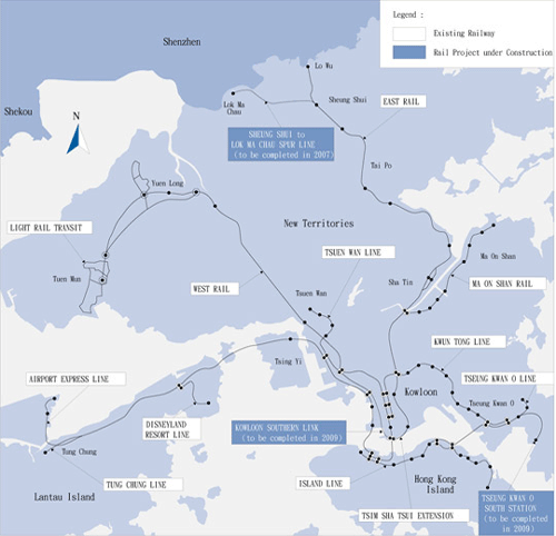
system, the rail systems are being extended to various parts of Hong Kong. The map
below shows the coverage of the existing railway network in Hong Kong as well as
three railway projects under construction.
Railway Projects
The 7.4-kilometre Spur Line will provide a second rail link to the Mainland to
relieve congestion at Lo Wu, which handled more than 92 million passengers in
2006. The Spur Line is under construction and will commence operation in mid-2007.
The 3.8-kilometre Kowloon Southern Link under construction will connect the
East Rail and the West Rail at the southern tip of the Kowloon Peninsula. On
completion in 2009, passengers will be able to interchange from the East Rail to the
West Rail and vice versa at Hung Hom.
The Tseung Kwan O South Station, an extension of the Tseung Kwan O Line, is
expected to be completed in 2009.
Railway Projects at the Planning Stage
The Northern Link will connect the West Rail at Kam Sheung Road to the
boundary crossing point at Lok Ma Chau, and together with the Spur Line, will form
a strategic corridor connecting the West Rail and the East Rail. The Hong Kong
section of the Guangzhou-Shenzhen-Hong Kong Express Rail Link will provide express
service to link up the urban area with the boundary. The line is expected to reduce
the rail travel time between Guangzhou and Hong Kong from the present 100
minutes to about 60 minutes. It will also link Hong Kong with Beijing and other major
Mainland cities via the Beijing-Guangzhou Passenger Line and the Hangzhou-Fuzhou-Shenzhen Passenger Line. It will also connect Hong Kong to cities in the Pearl River
Delta and Pan-Pearl River Delta via the Rapid Transit System now under development
on the Mainland.
Construction of the Shibi-Longhua section of the Guangzhou-Shenzhen-Hong
Kong Express Rail Link started in December 2005 and arrangements will be made to
synchronise the construction of the remaining section from Longhua to the boundary
with the Hong Kong section. The KCRC is conducting engineering and business
studies as well as preliminary site investigations for the Hong Kong section.
The West Island Line will be an extension of the existing MTR Island Line from
Sheung Wan to Kennedy Town with two intermediate stations at Sai Ying Pun and
University. The latest proposal for the South Island Line consists of two medium-capacity
rail lines, one from University to Wong Chuk Hang with intermediate stations
at Cyberport, Wah Fu and Aberdeen, and the other from Admiralty to South Horizons
with intermediate stations at Ocean Park, Wong Chuk Hang and Lei Tung.
The Sha Tin to Central Link will form a new strategic rail corridor from Sha Tin
to the Central Business District on Hong Kong Island. The latest proposal for the
project comprises two sections of railway lines — the East West Line connecting Tai
Wai with Hung Hom joining the Kowloon Southern Link and West Rail; and the North
South Line extending the existing East Rail across the harbour through the Fourth Rail
Harbour Crossing.
Road Projects under Construction
Major road projects under construction include:
| | • |
Route 8 (Cheung Sha Wan to Sha Tin): The dual three-lane carriageway will
serve as an additional link between Sha Tin and Kowloon and help divert
traffic from existing roads including the Lion Rock Tunnel and the Tate's Cairn
Tunnel. Construction started in October 2002 and will be completed in late
2007. |
| • |
Route 8 (Tsing Yi to Cheung Sha Wan): The dual three-lane carriageway will
provide an alternative route to the Route 3 Tsing Yi and Kwai Chung sections
and will serve as an access to the Container Terminals 8 and 9. Construction
started in April 2002 and will be completed in 2008 and 2009. |
| • |
Trunk Road T3: The dual two-lane trunk road in Tai Wai will link up Route 8
(Cheung Sha Wan to Sha Tin) with the existing Tai Po Road to help divert
traffic from several congested sections of Tai Po Road. Construction started in
March 2003 and will be completed by the end of 2007. |
| • |
Route 9, previously known as Route 5, between Shek Wai Kok and Chai Wan
Kok: The dual two-lane carriageway will provide a direct link between the
Shing Mun Tunnel and Tuen Mun Road, and will serve as a local link to the
western part of Tsuen Wan. Construction started in September 2002 for
completion by mid-2007. |
| • |
Widening of Castle Peak Road between Sham Tseng and Ka Loon Tsuen, Tsuen
Wan. The dual two-lane carriageway will cater for the increasing traffic
demand in the associated areas. Construction started in November 2001 and
is due for completion in 2007. |
| • |
Upgrading Castle Peak Road between Ka Loon Tsuen and Siu Lam into dual
two-lane carriageway standard. Construction started in March 2004 and is
scheduled for completion in mid-2007. |
| • |
Upgrading Tung Chung Road between Lung Tseng Tau and Cheung Sha into a
single two-lane road to improve Lantau Island's north-south access and to
enhance the safety and capacity of the existing substandard Tung Chung
Road. Construction started in June 2004 and is slated for completion in
September 2008. |
| • |
Improvements to San Tin Interchange by providing traffic lanes to Lok Ma
Chau Crossing from northbound San Tin Highway and westbound Fanling
Highway to bypass the elevated roundabout of the interchange. Construction
commenced in April 2005 and will be completed in 2007. |
Road Projects at the Planning Stage
A number of road construction/improvement projects are being planned to
further expand and improve the existing road network:
| | • |
Feasibility studies are being made of the possible highway options identified in
the Northwest New Territories Traffic and Infrastructure Review. The options
include Tuen Mun Eastern Bypass, Tuen Mun-Chek Lap Kok Link, Tuen Mun
Western Bypass and Link Options between Tuen Mun and Lantau. Another
feasibility study for Tsing Yi Lantau Link is scheduled to start in early 2007.
These projects are intended to cope with increasing road use in northwest
New Territories and north Lantau. |
| • |
Reconstruction and improvement of Tuen Mun Road is scheduled to start in
early 2008 for phased completion by the end of 2012. The project is to
upgrade the dual three-lane carriageway of the expressway section to current
expressway standards, including the provision of hard shoulder lanes wherever
practicable. Design and site investigation works started at the end of 2005.
The widening of Tuen Mun Road Town Centre Section is scheduled to start in
late 2008 for completion in 2010. |
| • |
Planning of the Central-Wan Chai Bypass is under way. It is the final stage of
a strategic highway running through the northern part of the Hong Kong
Island. It will connect the existing flyover near Rumsey Street in Central to the
existing Island Eastern Corridor. This dual three-lane carriageway will relieve
congestion along Connaught Road Central/Harcourt Road/Gloucester Road
corridor, and improve the network reliability of the east-west link. |
| • |
The preliminary engineering review of the Central Kowloon Route and
widening of Gascoigne Road Flyover was completed in 2006. The proposed
Central Kowloon Route will connect West Kowloon reclamation and the future
Kai Tak development with a 3.8 kilometre-long dual three-lane tunnel. The
project on the widening of Gascoigne Road Flyover is to upgrade the existing
single two-lane carriageway to dual two-lane configuration. Planning of the
two projects continues. |
| • |
Trunk Road T4 is a proposed dual two-lane carriageway, which will connect
Sha Tin Road with the future Trunk Road T3 and Shing Mun Tunnel Road, and
will serve as a bypass to Tai Po Road (Sha Tin section) and other district
distributor roads. Works is scheduled to start in 2007 for completion by 2010. |
Road Opening Works
Besides serving as carriageways for vehicles and pedestrians, roads also
accommodate different utility services, such as water and gas mains, sewers and
electricity and telephone cables. To cope with the increasing demand for utility
services and maintenance work, utility companies often have to excavate the
carriageways and footpaths to lay more pipes, cables and ducts, and to carry out
repair works. In order to regulate such activities, permits are issued for any excavation
work on carriageways and footpaths maintained by the Highways Department. In
2006, the department issued about 38 000 excavation permits.
The Highways Department has established a three-tier communication system
with management and staff of utility companies to coordinate and minimise traffic
disruption arising from street excavations.
The Land (Miscellaneous Provision) Ordinance provides the Government with the
legal framework to regulate street excavations so that they are carried out in an
orderly manner. The Government's cost in the management of street excavations is
recovered from excavation permit fees. In addition, an extra fee is charged to cover
the economic cost of any delay in completion of an excavation on the carriageway
without an acceptable reason. Such extra fees are currently set at $18,000, $7,000
and $1,500 per day respectively for a strategic street, sensitive street and other
streets. Under this system, all excavation works promoters are encouraged to carry
out better planning and coordination and complete their excavations on public streets
on time.
The Highways Department has a dedicated audit inspection team to ensure
excavation works are properly carried out, and an enforcement team to collect
evidence and initiate prosecution when the ordinance is violated.
Tsing Ma Control Area
The Tsing Ma Control Area, which opened to traffic in May 1997, is a
21-kilometre expressway network comprising the Tsing Kwai Highway, Cheung Tsing
Tunnel, Cheung Tsing Highway, North West Tsing Yi Interchange, Tsing Yi North
Coastal Road, Lantau Link, Ting Kau Bridge, part of the North Lantau Highway and
Ma Wan Road. The control area is operated and maintained by a private management
contractor.
The Lantau Link has a one-way toll collection arrangement. Vehicles travelling on
the Lantau Link are charged twice the single journey toll when they return from
Lantau Island or enter Ma Wan. The double toll ranges from $20 to $80 for different
types of vehicles. A daily average of 54 182 vehicles used the Lantau Link in 2006.
|