Existing Road Network
Hong Kong has 1 943 kilometres of roads and
1 087 road structures, three immersed-tube cross-harbour tunnels,
nine road tunnels and three major bridges. These facilities provide
a comprehensive road network for Hong Kong.
Major projects completed during the year included:
| • |
widening of Sai Sha Road to a dual two-lane
carriageway between Kam Ying Road and its junction with Trunk
Road T7 to cope with future growth in traffic demand from adjoining
private development; and |
| • |
the new boundary bridge between Lok Ma
Chau and Huanggang, which is a dual two-lane bridge, to relieve
the traffic burden on the existing boundary bridge. |
Existing Tunnels
The Cross-Harbour Tunnel, Eastern Harbour Crossing,
Tate's Cairn Tunnel, Western Harbour Crossing and Tai Lam Tunnel
were built by the private sector under 'Build, Operate and Transfer'
franchises.
The 1.9-kilometre Cross-Harbour Tunnel connects
Causeway Bay on Hong Kong Island and Hung Hom in Kowloon. The franchise
for the tunnel, which was opened in 1972, ended on August 31, 1999,
and the facility was handed back to the Government. With a daily
patronage of 121 700 vehicles, it is one of the world's busiest
four-lane road tunnels. The tolls ranged from $8 to $30 for different
types of vehicles.
The two-kilometre Eastern Harbour Crossing was
opened in 1989. It links Quarry Bay on Hong Kong Island and Cha
Kwo Ling in Kowloon. A daily average of 73 500 vehicles used
the tunnel. Tolls ranged from $8 to $45.
The two-kilometre Western Harbour Crossing is
the first six-lane cross-harbour road tunnel in Hong Kong. Opened
in 1997, it links Sai Ying Pun on Hong Kong Island and the West
Kowloon Reclamation near Yau Ma Tei in Kowloon. It was used by an
average of 39 200 vehicles daily. Statutory tolls ranged from $30
to $185. The tunnel company offers concessionary tolls and the actual
tolls ranged from $22 to $110.
The four-kilometre Tate's Cairn Tunnel, the longest
road tunnel in Hong Kong, was opened in 1991, providing an additional
direct road link between the north-eastern New Territories and Kowloon.
It was used by an average of 61 100 vehicles daily. Tolls ranged
from $10 to $20.
The 3.8-kilometre Tai Lam Tunnel and the 6.3-kilometre
Yuen Long Approach Road form Route 3 (Country Park section), which
extends from Ting Kau to Au Tau. Opened in May 1998, it was used
by an average of 45 400 vehicles daily. Statutory tolls ranged from
$20 to $90. The tunnel company offers concessionary tolls and the
actual tolls ranged from $17 to $75.
The 2.4-kilometre Discovery Bay Tunnel Link, which
comprises a 630-metre single tube two-way tunnel and a 1 770-metre
approach road, is operated and maintained by the Discovery Bay Road
Tunnel Company Limited, which also built it. It extends from Discovery
Bay through Yi Pak Au to Cheung Tung Road. The tunnel link is only
open to vehicles providing goods or services to Discovery Bay residents.
Opened in May 2000, the tunnel link was used by an average of 800
vehicles daily. It has a one-way toll collection arrangement. Vehicles
are charged a single journey toll when they enter Discovery Bay.
The tolls ranged from $50 to $250.
The Government owns seven of the road tunnels
(Lion Rock, Aberdeen, Airport, Shing Mun, Tseung Kwan O, Cheung
Tsing and Cross-Harbour), which are managed and operated by private
companies under management contracts. Tolls are set and monitored
by the Government. Use of the Airport Tunnel and Cheung Tsing Tunnel
is free of charge.
| • |
The 1.4-kilometre Lion Rock Tunnel, linking
Kowloon and Sha Tin, began single-tube operation in 1967, with
a second tube added in 1978. The tunnel was used by 87 700 vehicles
daily. The toll was $8. |
| • |
The 1.9-kilometre Aberdeen Tunnel, opened
in 1982, links the northern and southern parts of Hong Kong
Island. It was used by 57 600 vehicles daily. The toll was $5. |
| • |
The 1.3-kilometre toll-free Airport Tunnel
between Hung Hom and Kowloon Bay passes under the former airport
site at Kai Tak and was opened in 1982. It was used by 59 100
vehicles daily. |
| • |
The 2.6-kilometre Shing Mun Tunnel between
Sha Tin and Tsuen Wan was opened in 1990. The tunnel was used
by an average of 53 300 vehicles daily. The toll was $5. |
| • |
The 900-metre Tseung Kwan O Tunnel, opened
in 1990, links Kowloon and the new town at Tseung Kwan O. It
was used by 67 700 vehicles daily. The toll was $3. |
| • |
The 1.6-kilometre toll-free Cheung Tsing
Tunnel was opened in 1997 and links Kwai Chung and Tsing Yi.
It was used by 84 100 vehicles daily. |
Existing Rail Network
Railways form a vital part of the transport network
of Hong Kong and are essential for continuous economic, social and
land development. The existing rail network in Hong Kong comprises
a heavily utilised urban railway (the MTR); a busy railway from
Kowloon to the boundary at Lo Wu (East Rail), which was extended
from Hung Hom to East Tsim Sha Tsui and from Tai Wai to Wu Kai Sha
in 2004; a railway connecting northwest New Territories with Kowloon
(West Rail); a modern light rail Network serving Tuen Mun and Yuen
Long including the Tin Shui Wai new town (Light Rail Transit); and
a dedicated premium class railway to Hong Kong International Airport
at Chek Lap Kok (Airport Express Line). There is also a traditional
street tramway and a funicular tramway to the Peak on Hong Kong
Island. East Rail, West Rail and Light Rail are operated by the
KCRC which is a public corporation wholly owned by the Government.
The MTR and the Airport Express Line are operated by MTRCL, a listed
company with the Government as the major shareholder. The Tramway
and the Peak Tram are owned by private operators.
The railways in Hong Kong accounted for about
30 per cent of daily domestic passenger travel and about 70 per
cent of land based cross-boundary trips to the Mainland. In line
with the Government's transport policy to use rail as the backbone
of our public transport system, the rail systems are being extended
to various parts of Hong Kong.
Railway Projects
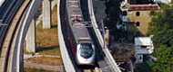
Comprising three rail projects, the East Rail
extensions expand the existing East Rail to reach East Tsim Sha
Tsui, Ma On Shan and Lok Ma Chau. The 1.1-kilometre East Rail Tsim
Sha Tsui Extension was opened on October 24. It connects the MTR
Tsim Sha Tsui Station with a new KCR East Tsim Sha Tsui Station
via an extended subway system to enable passenger interchange. The
second extension, the 11.4-kilometre Ma On Shan Rail, was opened
on December 21. It serves the Sha Tin and Ma On Shan areas with
nine stations at Wu Kai Sha, Ma On Shan, Heng On, Tai Shui Hang,
Shek Mun, City One, Sha Tin Wai, Che Kung Temple and Tai Wai, where
passengers can interchange with East Rail. The third extension,
the 7.4-kilometre Sheung Shui to Lok Ma Chau Spur Line, aims to
provide a second rail link to the Mainland to relieve cross-boundary
congestion at Lo Wu, which handles in excess of 85 million passengers.
The Spur Line is under construction and is planned to start operation
in mid-2007.
The 3.5-kilometre Disneyland Resort Line will
operate initially as a single-track railway providing a shuttle
service between a new MTR station at Hong Kong Disneyland and a
new MTR station at Sunny Bay where passengers can interchange with
the existing Tung Chung Line. The rail line is under construction
and is planned to open in mid-2005 to tie in with the opening of
the Disneyland theme park.
The 3.8-kilometre Kowloon Southern Link will connect
East Rail and the West Rail at the southern tip of the Kowloon Peninsula.
Upon completion, passengers will be able to travel through East
Rail and West Rail via Hung Hom.
The Sha Tin to Central Link will form a new strategic
rail corridor from Sha Tin to the Central Business District on Hong
Kong Island via the proposed South East Kowloon Development area.
The latest proposal for the project is to divide the railway into
two sections, the East West Line connecting Tai Wai with Hung Hom
to join the Kowloon Southern Link and West Rail; and the North South
Line extending the existing East Rail to Central through the Fourth
Rail Harbour Crossing. The detailed implementation programme will
be subject to further study on feasibility and other reviews on
planning development along the railway line.
Railway Projects under Planning
The Northern Link will connect West Rail at Kam
Sheung Road to East Rail at Kwu Tung and to the boundary crossing
point at Lok Ma Chau. The Regional Express Line (REL) is envisaged
to provide an express rail service to link up the urban area with
the boundary. The REL will form the Hong Kong section of the Guangzhou-Shenzhen-Hong
Kong Express Rail Link (ERL), which is expected to reduce the journey
time between Guangzhou and Hong Kong from the existing 100 minutes
to about an hour and will have the opportunity for access to Beijing
and other major Mainland cities via the future Beijing-Guangzhou
Passenger Line. A joint investigative study is being conducted by
the HKSAR Government and the Mainland authorities on the feasibility
of the ERL. MTRCL and the KCRC had provided in their joint merger
report an assessment on using West Rail and the Northern Link to
form the Hong Kong section of the ERL, which they submitted to the
Government for consideration in September. The KCRC is conducting
a further study of this alignment of the Hong Kong section of the
ERL in the context of its Northern Link study.
The latest scheme of the West Hong Kong Island
Line/South Hong Kong Island Line project consists of a single track
heavy rail extension of the existing Hong Kong Island Line from
Sheung Wan to a new station at Sai Ying Pun together with two medium
capacity rail lines, one from Sai Ying Pun to Wong Chuk Hang and
the other from South Horizons to Admiralty with interchange at Wong
Chuk Hang. Intermediate stations will be provided at University,
Kennedy Town, Cyberport, Wah Fu, Aberdeen, Lei Tung and Ocean Park.
The Port Rail Line (PRL) involves a new freight
rail connection from Lo Wu to a new terminal at Kwai Chung. PRL
will allow freight from the deep hinterland of China (i.e. beyond
Guangdong) to access the container ports at Kwai Chung. The viability
of this line will hinge on the growth of rail-borne cross-boundary
freight traffic.
Road Projects Under Construction
Majar road projects being implemented include:
| • |
Deep Bay Link (DBL) and Hong Kong-Shenzhen
Western Corridor (HK-SWC): construction of the DBL and the HK-SWC
commenced in June 2003 and August 2003 respectively for completion
in end-2005. The HK-SWC will become Hong Kong's fourth vehicular
boundary crossing while the DBL will link it with the local
transport network. |
| • |
Widening of Yuen Long Highway between
Lam Tei and Shap Pat Heung Interchange: this section of Yuen
Long Highway is being widened to a dual three-lane carriageway
to cope with the anticipated growth in traffic. Works commenced
in July 2003 for completion by end 2005. |
| • |
Route 8 (Cheung Sha Wan to Sha Tin):
construction commenced in October 2002 for completion in mid-2007.
This dual three-lane carriageway will serve as an additional
link between Sha Tin and Kowloon and relieve traffic on existing
links including the Lion Rock Tunnel and the Tate's Cairn Tunnel. |
| • |
Route 8 (Tsing Yi and Cheung Sha Wan):
construction commenced in April 2002 for completion in 2008.
This dual three-lane carriageway will provide an alternative
route to the Route 3 Tsing Yi and Kwai Chung sections and access
to the Container Terminals 8 and 9. |
| • |
Trunk Road T3: this dual two-lane trunk
road in Tai Wai links Route 8 (Cheung Sha Wan to Sha Tin) with
the existing Tai Po Road and will help relieve traffic congestion
by providing a bypass for several congested sections of Tai
Po Road. Construction commenced in March 2003 for completion
in 2007. |
| • |
Route 9 (previously known as Route 5)
between Shek Wai Kok and Chai Wan Kok: this dual two-lane carriageway
will provide a direct link between the Shing Mun Tunnel and
Tuen Mun Road as well as a local link to western Tsuen Wan.
Construction commenced in September 2002 for completion in 2006. |
| • |
Chok Ko Wan Link Road (Penny's Bay section):
this dual three-lane carriageway will be the access road to
developments at Penny's Bay, including Hong Kong Disneyland.
Construction started in August 2002 for completion in August
2005. |
| • |
Castle Peak Road between Sham Tseng and
Ka Loon Tsuen, Tsuen Wan: this section of Castle Peak Road is
being widened to a dual two-lane carriageway to cater for increasing
traffic demand. Works commenced in November 2001 for completion
in 2006. |
| • |
Salisbury Road Underpass: this dual two-lane
underpass along Salisbury Road will improve the traffic capacity
at the junction of Salisbury Road and Chatham Road South. Works
started in March 2001 for completion in February 2005. The project
also involves widening the section of Salisbury Road between
Wing On Plaza and Canton Road. |
| • |
Improvement to Castle Peak Road between
Ka Loon Tsuen and Siu Lam by upgrading it to dual two-lane carriageway
standard. Works commenced in March for completion in mid-2007. |
| • |
Improvement to Tung Chung Road between
Lung Tseng Tau and Cheung Sha by upgrading it to a single two-lane
road to improve Lamma Island's north-south access and to enhance
the safety and capacity of the existing substandard Tung Chung
Road. Construction works commenced in June for completion in
end 2006. |
The new boundary bridge at the Sha Tau Kok crossing,
which is a single two-lane bridge, will improve traffic flow. Works
commenced in May for completion in January 2005.
Road Projects Under Planning
A number of road construction/improvement projects
are under planning to further expand and improve the existing road
network:
| • |
The Hong Kong-Zhuhai-Macao Bridge Advance
Work Coordination Group has embarked on a feasibility study
on the bridge. An investigation and preliminary design study
on the Hong Kong section of the bridge and the related connecting
infrastructure is under way; |
| • |
Reconstruction and improvement of Tuen
Mun Road will commence tentatively in end 2005 for completion
in end-2011. The project is intended to upgrade the carriageway
to the current expressway standard to enhance road safety and
to cater to growing traffic demand. Design and site investigation
works started in mid-2004. |
| • |
Planning of the Central-Wan Chai Bypass
and the Island Eastern Corridor Link is under way. This dual
three-lane carriageway aims at relieving traffic congestion
along Connaught Road Central/Harcourt Road/Gloucester Road,
which is the key east-west traffic route along the northern
shore of Hong Kong Island linking the Central, Wan Chai and
Causeway Bay areas. |
| • |
Improvements to San Tin Interchange by
providing traffic lanes to Lok Ma Chau Crossing from northbound
San Tin Highway and westbound Fanling Highway to bypass the
elevated roundabout of the interchange. Construction works would
commence in April 2005 for completion in March 2007. |
Road Opening Works
Besides serving as carriageways for vehicles and
pedestrians, roads also accommodate various utility services, such
as water and gas mains, sewers and electricity and telephone cables.
To cope with the increasing demand for utility services and maintenance
work, utility companies often have to excavate the carriageways
and footpaths to lay more pipes, cables and ducts, and to carry
out repair work. In order to regulate such activities, any excavation
work on carriageways and footpaths maintained by the Highways Department
needs an excavation permit. In 2004, the Highways Department issued
about 43 000 excavation permits.
To coordinate and monitor excavation works more
effectively and to minimise traffic disruption, the Highways Department
has established a three-tier communication system with participants
ranging from high level management to working level staff of utility
companies and relevant government departments. A computerised utility
management system has been in use since 1997 to improve coordination
and minimise inconvenience to road users.
In order to strengthen controls on excavation
works and to minimise delays and inconvenience to the public, the
Land (Miscellaneous Provision) Ordinance was amended by the Land
(Miscellaneous Provisions) (Amendment) Ordinance 2003, with effect
from April 1, 2004. The amended Land (Miscellaneous Provision) Ordinance
provides the Government with the legal framework to take enforcement
action against violations of the ordinance and to charge for excavation
permit fees. In addition, a daily economic cost is charged to permittees
who cannot complete their excavations in carriageways within the
permit period.
A dedicated audit inspection team has been established
in the Highways Department to ensure that excavation works are properly
carried out. An enforcement team has also been set up to collect
evidence and initiate prosecution when the ordinance is violated.
To recover the administrative cost for issuing
excavation permits and carrying out audit inspections, the Government
charges fees according to the 'user-pays' principle. The issue fee
for an excavation permit on public roads is $1,860 and a daily fee
of $32 is charged to cover each day of the excavation. A further
fee of $590 is charged for issuing an extension to the excavation
permit.
For any delay without an acceptable reason, a
daily economic cost is charged. For strategic streets, sensitive
streets and other streets, the respective economic cost is $18,000,
$7,000 and $1,500 per day of such extension. With the charging system,
all excavation works promoters are encouraged to carry out better
planning and to complete excavation works on public roads on time.
Existing Control Area
The Tsing Ma Control Area (TMCA), which was opened
to traffic in May 1997, is a 21-kilometre expressway network comprising
the Tsing Kwai Highway, Cheung Tsing Tunnel, Cheung Tsing Highway,
North-West Tsing Yi Interchange, Tsing Yi North Coastal Road, Lantau
Link, Ting Kau Bridge, part of the North Lantau Highway and Ma Wan
Road. The TMCA is operated and maintained by a private management
contractor.
The Lantau Link has a one-way toll collection
arrangement. Vehicles travelling on the Lantau Link are charged
twice the single journey toll when they return from Lantau Island
or enter Ma Wan. The double toll ranges from $20 to $80 for different
types of vehicles. A daily average of 48 000 vehicles used the Lantau
Link in 2004.
|